
Voxel Terrain (Processed)
A Voxel Terrain entity represents a fully volumetric terrain surface. Unlike mesh-based terrain, this format captures both surface continuity and sub-surface volume, making it ideal for detailed rendering and volumetric analysis—such as detecting changes in terrain over time.
Voxel Terrain entities can be generated from point clouds and heightmaps, and they may also include associated Ortho-Imagery, whether supplied by the user or auto-generated during import.
🌍 Voxel Terrain
Generate continuous voxel-based terrain models from point clouds or heightmaps. Supports integration with ortho-imagery and computed normals.
→ Ideal for topographic visualization and volume change detection.
Creating a Voxel Terrain
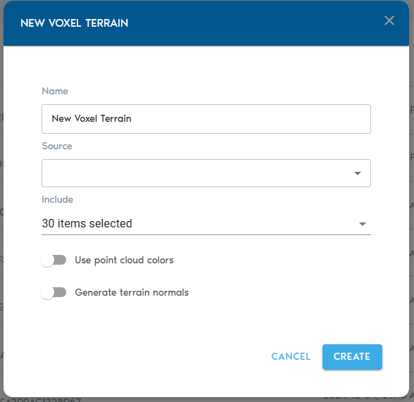
3. Fill in the configuration fields:
|
Field |
Description
|
|
Item Name |
A descriptive name for the new terrain entity.
|
|
Source |
Select one or more Point Cloud or Heightmap entities to be used as the base for the terrain.
|
|
Include (Point Cloud only) |
Choose which point classifications to include in the terrain model. By default, all points are used.
|
|
Ortho-Imagery |
Select one or more Ortho-Imagery entities to be draped over the terrain. These can be aerial photos or computed textures.
|
|
Detail Recovery – Use Point Cloud Colors |
If selected, the system will use RGB values from point clouds (if available) to generate an Ortho-Imagery set automatically.
|
|
Detail Recovery – Generate Terrain Normals |
Requests the system to generate a high-frequency elevation detail set in the form of a normal map, enhancing terrain realism. |
Finalizing and Viewing
- Click “Create” to start the voxelization and processing workflow.
- Progress can be monitored in the project’s “Pending” section.
Once processing is complete:
- Click “View” next to the Voxel Terrain entity in the Catalog to open it directly.
- Alternatively, create a View entity and set the Voxel Terrain as its source to include it in a broader visualization.