
Voxel Terrain
TheA Voxel Terrain entity represents a fully volumetric terrain.terrain Itsurface. featuresUnlike amesh-based continuousterrain, surface,this soformat captures both surface continuity and sub-surface volume, making it is ideal for detailed rendering and volumetric analysis—such as detecting changes in terrain surfaces.over Also, since the entity is fully volumetric, it can be used as an operand in complex volumetric queries like detecting volume changes from one dataset to another.time.
It is possible to create Voxel Terrain entities from point clouds and heightmaps. Voxel Terrain entities can be generated from point clouds and heightmaps, and they may also haveinclude associated Ortho-Imagery, sets associated with them. These sets can bewhether supplied by the user (like aerial photography) or computedauto-generated byduring the Voxel Farm system (like detail normal maps).import.
To createCreating a new Voxel Terrain
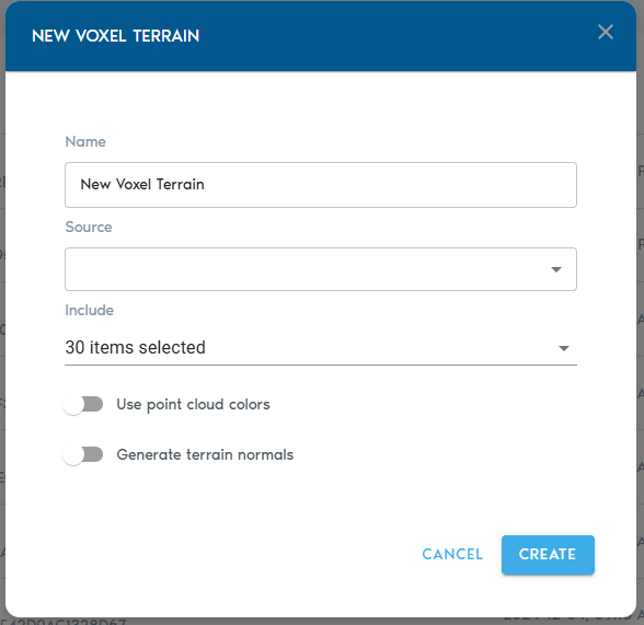
3. Fill in the configuration fields:
|
Field |
Description
|
|
Item Name |
A
|
|
Source |
|
|
Include (Point Cloud only) |
|
|
Ortho-Imagery |
|
|
Detail Recovery – Use |
|
|
Detail Recovery – Generate |
Requests the |
Finalizing and Viewing
- Click
on“Create” tobeginstart the voxelizationprocess.andYouprocessing workflow. - Progress can
trackbethe upload operation from the “Pending” sectionmonitored in the project’spage“Pending” section.
Once the processing is complete,complete:
- Click
view“View” next to thenewVoxel Terrain entityby clicking on the “View” buttonin theentity’sCatalogrowtoinsideopentheitCatalogdirectly. - Alternatively,
you maycreate a View entitythatandusesset thenewlyVoxelcreated entityTerrain asaits sourcedataset.to include it in a broader visualization.