Project Coordinate System
Use the “Coordinates” section when creating or editing a project to configuredefine theits unitsunits, reference systems, and projectionspatial system used by the project.framework.
TheThese followingsettings tableare listsessential thefor propertiesaligning foundall inspatial thedata Coordinatescorrectly sectionwithin your project and describesensuring theirconsistency use:across datasets.
|
A horizontal datumField is a reference system used to define positions on the Earth's surface using latitude and longitude. It's essentially a coordinate system that helps pinpoint locations geographically. This system relies on a mathematical model of the Earth's shape, often an ellipsoid, and a specific anchor point.
|
A vertical datumDescription is a reference surface used to define vertical positions, essentially serving as the "zero point" for measuring elevations and depths on Earth. It's crucial for consistent and accurate height measurements in various fields like surveying, hydrography, and navigation.
|
|
Time Zone
|
TheSets the local time zone for the project’sproject location. This helps timestamp data and coordinate updates across time-based processes.
|
|
Horizontal datumDatum
|
HorizontalA horizontal datum useddefines byhow latitude and longitude coordinates are calculated based on the project.shape These areof the supportedEarth. VoxelSpace supports the following horizontal datums:
• WorldWGS Geodetic72
• SystemWGS 197284
• GRS 80
• NAD27
• NAD83
• NAD83 (WGS2011)
• 72)
World Geodetic System 1984 (WGS 84)
Geodetic Reference System 1980 (GRS 80)
North American Datum 1927 (NAD27)
North American Datum (NAD83)
North American Datum (NAD83 2011)
• North American Datum (NAD83 HARN)
• NorthGDA94
• AmericanETRS89
• Datum (NAD83 CSRS)
Geocentric Datum of Australia 1994 (GDA94)
European Terrestrial Reference System 1989 (ETRS89)
Australian Geodetic Datum 1966 (AGD66)
|
Vertical datum
|
Vertical datum used by the project. These are the supported vertical datums:
World Geodetic System 1984 (WGS 84)
National Geodetic Vertical Datum 1929 (NGVD 29)
North American Vertical Datum 29 (NAVD 29)
Canadian Geodetic Vertical Datum 2013 (CGVD 2013)
Canadian Geodetic Vertical Datum 1928 (CGVD 28)
Denmark Vertical Reference (DVR 90)
Norway Normal Null 2000 (NN2000)
Norway Normal Null 1954 (NN54)
Deutsches Haupthoehennetz 1992 (DHHN92)
North American Vertical Datum 1988 (NAVD 88)
North American Vertical Datum 1988 (NAVD 88 GEOID12B)
North American Vertical Datum 1988 (NAVD 88 GEOID12A)
North American Vertical Datum 1988 (NAVD 88 GEOID12)
North American Vertical Datum 1988 (NAVD 88 GEOID09)
North American Vertical Datum 1988 (NAVD 88 GEOID06)
North American Vertical Datum 1988 (NAVD 88 GEOID03)
North American Vertical Datum 1988 (NAVD 88 GEOID99)
North American Vertical Datum 1988 (NAVD 88 GEOID96)
|
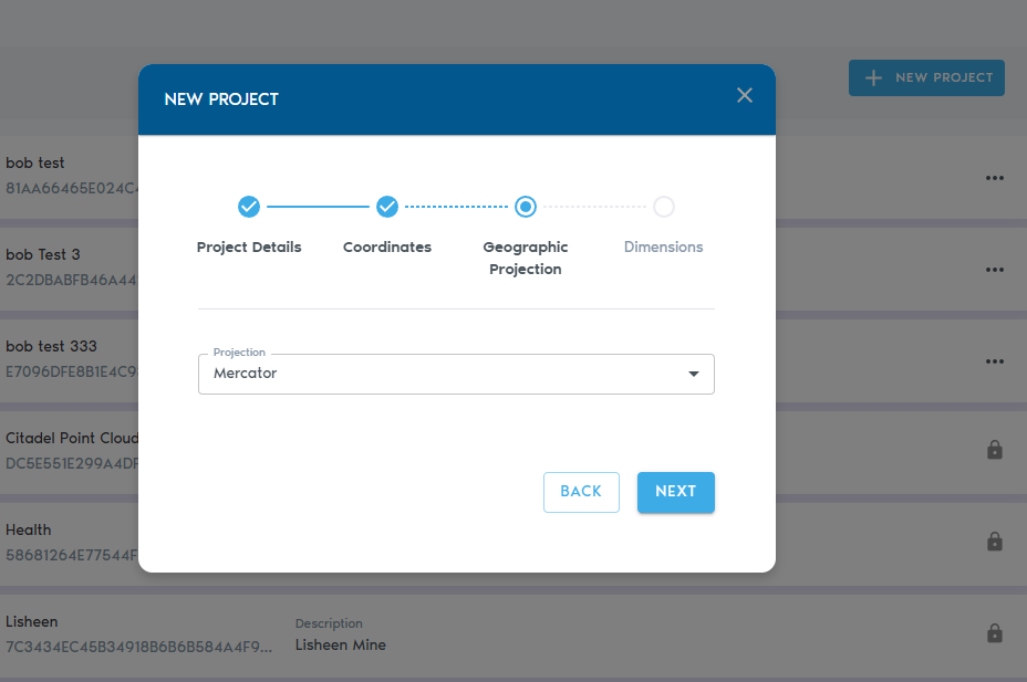
Projection
|
Projection used by the project. These are the supported projections:
Latitude Longitude
Longitude Latitude
Earth Centered Earth Fixed
Mercator
Universal Transverse Mercator (UTM)
Transverse Mercator
Lambert conformal conic
AEAC
AMG
MGA
|
Units
|
Determines whether units represent meters of feet.AGD66
|
|
VoxelVertical SizeDatum
|
VoxelsA arevertical cubes.datum This parameter determinessets the lengthreference allsurface sidesused into ameasure voxel’selevation cube.or depth. VoxelSpace supports the following vertical datums:
• WGS 84
• NGVD 29
• NAVD 29
• NAVD 88 (GEOID variants 96–12B)
• CGVD 28
• CGVD 2013
• DVR 90
• NN2000
• NN54
• DHHN92
|
|
Project Origin X, Y, ZProjection
|
The origin coordinates ofDefines the project,map projection used to represent the Earth’s curved surface in units.2D/3D Thisspace. pointSupported becomesprojections ainclude: reference
• pointLatitude/Longitude
• forLongitude/Latitude
• theEarth-Centered project.Earth-Fixed (ECEF)
• Mercator
• Universal Transverse Mercator (UTM)
• Transverse Mercator
• Lambert Conformal Conic
• AEAC
• AMG
• MGA
|
|
Min X, Y, Z (read-only)Units
|
MinimumChoose possiblewhether coordinatesyour inproject theuses project.meters or feet for all distance measurements.
|
|
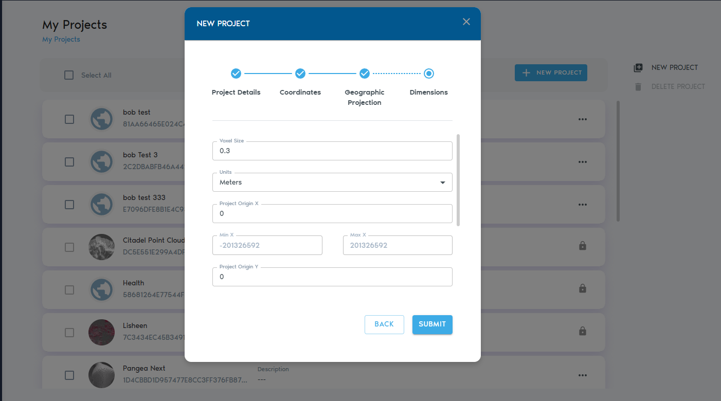
Voxel Size
|
Voxels are 3D cubes. This setting defines the edge length of each voxel (in project units).
|
|
Project Origin (X, Y, Z)
|
The origin point of the project’s coordinate space. All spatial data will be referenced relative to this point.
|
|
Min X, Y, Z (Read-only)
|
The minimum bounds of the coordinate system in each axis. Calculated automatically.
|
|
Max X, Y, Z (read-Read-only)
|
MaximumThe possiblemaximum coordinatesbounds of the coordinate system in theeach project.axis. Calculated automatically.
|
TheNext nextSteps
pageAfter is aboutsetting the geographiccoordinate Projectionsystem, click “Next” to continue defining the dimensions and spatial extent of your project.

Click on next to add the dimensions of your project