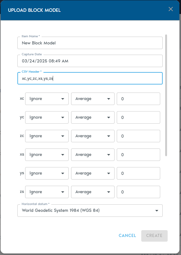
# Block Model (Raw Data) A **Block Model** entity stores structured 3D block data—typically used in resource estimation, geological modeling, and spatial analysis. The model is uploaded as a **comma-separated ASCII text file**, where each row represents an individual block. Import structured block models in CSV format. Each row represents a volumetric block with positional and attribute data. → *Commonly used in mining and geological modeling.*
---
**Uploading a Block Model** 1. Navigate to your project’s **Catalog** section and click **“Add Object.”** 2. From the dropdown, select **“Block Model.”** [![image.png](https://help.mystart.com/uploads/images/gallery/2025-03/scaled-1680-/MFGimage.png)](https://help.mystart.com/uploads/images/gallery/2025-03/MFGimage.png) 3\. Fill out the following fields:
**Field** **Description**
**Item Name** A descriptive name for the new block model entity.
**Capture Date** *(Optional)* The original date the model data was captured.
**CSV Header** A comma-separated line of headers that define how each column in the block model should be interpreted. (Details below.)
**Horizontal Datum** The horizontal reference system used in the model.
**Vertical Datum** The vertical reference system used for elevation values.
**Projection** The map projection used in the dataset.
**Horizontal Units** Units for X and Y coordinates (e.g., meters, feet).
**Vertical Units** Units for Z coordinates (e.g., meters, feet).
**CSV Header** The **CSV Header** field defines how each column in your file should be interpreted. For example, a header line like: XC,YC,ZC,XL,YL,ZL,AU,CU …will produce a list of **Column Definitions** for each value, allowing you to specify their role in the model.
[![image.png](https://help.mystart.com/uploads/images/gallery/2025-03/scaled-1680-/WvSimage.png)](https://help.mystart.com/uploads/images/gallery/2025-03/WvSimage.png) [![image.png](https://help.mystart.com/uploads/images/gallery/2025-03/scaled-1680-/fkFimage.png)
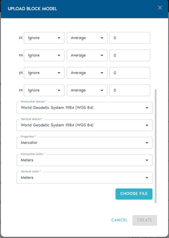
](https://help.mystart.com/uploads/images/gallery/2025-03/fkFimage.png)
**Column Types** Each column must be assigned a **Type**, which tells the system how to process it:
**Type** **Purpose**
**Ignore** Exclude this column from processing.
**Set** The column contains a small set of repeating categorical values.
**Value** Numeric values (e.g., grades, densities).
**Block Centroid X/Y/Z** Coordinates for the block’s center point.
**Block Origin X/Y/Z** Coordinates for the block’s origin corner.
**Block Dimension X/Y/Z** Size of the block along each axis.
**Note:** You must choose **either** block centroids **or** block origins for positioning—not both. Using both will result in an input error. **Level of Detail (LOD) Aggregation** Each numeric column (e.g., grades or quantities) can also be configured with a **Level of Detail (LOD) operation**, which determines how values are aggregated in lower-resolution views:
**LOD Option** **Description**
**Average** Average of all higher-resolution values.
**Min** Minimum value from the finer data.
**Max** Maximum value from the finer data.
**Add** Sum of all values (ideal for counters).
**Multiply** Product of all values.
**Uploading the File** - Click **“Choose File”** to upload your block model file (CSV or TXT format). - You may also upload a **ZIP archive** that contains your ASCII file.
---
Click **“Create”** to start the upload process. You can monitor the progress in the project’s **“Pending”** section.